Il relitto di Grado 2 (III sec. a.C.) e il ruolo del commercio trasmarino all’alba dell’espansione romana nel Nord Est d'Italia
Research
Il relitto di Grado 2 (III sec. a.C.) e il ruolo del commercio trasmarino all’alba dell’espansione romana nel Nord Est d'Italia
Responsabile scientifico: Matteo Cadario
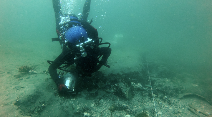
The Grado 2 wreck lies at a depth of 19 metres, approximately 7 nautical miles offshore from the coast of Grado. Based on the underwater investigations conducted so far, it appears that the archaeological deposit consists of amphorae of the Greco-Italic type. An analytical study of the recovered material, with the related production of documentation, will be integrated into a purpose-built “intra-site” GIS, while comparisons with other archaeological deposits will be organised using available data, potential ceramic fabric analyses, and targeted investigations.
Objectives
The main objective of the research is the collection of data acquired so far on the cargo of the wreck, aimed both at a detailed study of this submerged archaeological area and at situating it within the broader framework of Roman maritime trade. Particular attention will be given to the connections between this offshore site and other Roman-era wrecks, in order to identify the main trade routes and ports in this sector of the Adriatic Sea.
Activities and results in the field of DH
The study of materials recovered from the Grado 2 wreck has been initiated, including both those temporarily held in the DIUM Laboratory of Underwater Archaeology and those stored in the deposits of the Superintendence in Aquileia. In addition to standard photographic and graphic documentation, a 3D survey of the main diagnostic finds has been carried out. The study of the broader historical and archaeological context has required the collection of all published material through a thorough bibliographic review, while unpublished information has been obtained from the regional archives of the heritage authorities.
Field activities have focused on two new wrecks. The first, designated Grado 5, lies approximately 700 metres from the seafront of Grado. The initial investigation allowed the identification and survey of a section of the ship’s hull, constructed with mortise-and-tenon joinery, which, based on the observed material (archaic Lamboglia 2), can be dated to between the late 2nd and early 1st centuries BCE. The second wreck is located within the Grado Lagoon, a few dozen metres south of Pampagnola Island. Here, from the bank of the “litoranea veneta” canal, an alignment of over ten metres of keel timbers and planking, assembled using the mortise-and-tenon technique, was observed and recorded. In the absence of excavation to determine the site’s chronology, radiometric dating was used, placing it in the 3rd–4th centuries CE. For the documentation of both wrecks, in addition to direct measurements of some structural elements, Computer Vision techniques (Structure from Motion) were employed, allowing the construction of a 3D model from a cloud of photographic pixels, in this case using Agisoft Metashape software.
Under concession, the research pursues the goal of studying these areas through non-invasive geophysical surveys, such as side-scan sonar and multibeam, as well as direct underwater verification of any anomalies. The use of drones is also planned, both to document the research phases and to detect further anomalies in areas with shallower water levels.